Grenada and Carriacou
The map opens as you scroll to it
Grenada's south-coast bays and boatyards, the cruisers' summer home, and Carriacou's Tyrrel Bay and Sandy Island just to the north.
JFMAMJJASOND
The region
Grenada, the Spice Island, is the southern end of the Windward chain and a favourite base for long-term cruisers. St George's has one of the prettiest harbours in the Caribbean, with Port Louis Marina in the lagoon. Grand Anse beach stretches to the south.
The south coast is where cruisers gather: a series of deep, reef-fringed bays (Prickly Bay, True Blue, Mount Hartman Bay, Hog Island, Clarkes Court Bay, St David's) with marinas, boatyards and a busy, friendly community. Grenada sits near the southern edge of the hurricane belt, so many boats spend the summer here or haul out in its yards, although the island is not immune; Hurricane Ivan struck in 2004.
Carriacou, about 30 miles north, belongs to Grenada. Tyrrel Bay is a large, calm anchorage with a boatyard, and Hillsborough is the main town and port of entry. Sandy Island, a sliver of sand with palm trees, lies in a marine protected area with moorings. Petite Martinique is the small island to the east. Carriacou was badly hit by Hurricane Beryl in July 2024.
Winds and season
Trade winds from the east, 15 to 20 knots, and a south-east swell that can make some south-coast bays roll. The dry season runs roughly from January to May; the wet season from June to December brings heavier showers. The Atlantic hurricane season runs from 1 June to 30 November, with the most activity from August to October. Grenada is south of the main track, which is why many boats summer here; check your insurance for the latitude limits.
The region in numbers
Counted from the records on Boat Almanac, November 2026. A number missing or wrong? Correct it on the place's page, and it helps the next crew planning here.
Getting there
- Maurice Bishop (GND), Saint George's about 36 km from the middle of the region
- Argyle (SVD), Kingstown about 110 km from the middle of the region
- A.N.R. Robinson (TAB), Scarborough about 151 km from the middle of the region
Straight-line distance; by road it is usually a third longer. Each marina page gives its own nearest airports.
Want company on these waters? Find a buddy boat or crew on Sail together.
Where to stop
- Port Louis Marina, St George's
Marina in the lagoon next to the capital, with full services. - Prickly Bay
Port of entry and busy cruiser anchorage with a marina and boatyard. - Mount Hartman Bay
Well-protected bay behind reefs with a marina. - Hog Island
Sheltered anchorage among small islands on the south coast. - Clarkes Court Bay and Woburn
Large bay with marinas and haul-out, protected by reefs. - Tyrrel Bay, Carriacou
Large calm bay with boatyard and haul-out. - Hillsborough, Carriacou
Port of entry and main town; open roadstead. - Sandy Island, Carriacou
Marine protected area with moorings and a fee.
Been here? Rate a cove in a few taps and the next skipper will thank you.
Anchoring and mooring
Most south-coast bays have reefs at their entrances: enter in good light with the chart. Holding is generally good in sand and mud. In Tyrrel Bay there is plenty of room on a sand bottom.
A one-week route
A realistic loop for a week, with short days you can stretch or cut to the weather. Check every leg on the chart and the route planner.
- Arrive at Prickly Bay and clear in.
- Prickly Bay to Hog Island or Clarkes Court Bay along the south coast.
- Round Point Salines to St George's, Port Louis Marina.
- Up the west coast, snorkel the underwater sculpture park at Moliniere on a park mooring.
- St George's to Tyrrel Bay, Carriacou (about 35 NM).
- Sandy Island for the day, back to Tyrrel Bay.
- Hillsborough to clear out, or on to Petite Martinique.
Rules and protected areas
Clearing in: Ports of entry include St George's (Port Louis), Prickly Bay and, on Carriacou, Hillsborough and Tyrrel Bay. Grenada uses an online pre-arrival system; register before you arrive and clear with Customs and Immigration at the port. Step by step in Arriving by boat in Grenada.
Fuel, water, repairs and supplies
Grenada has some of the best yacht services in the southern Caribbean: several haul-out yards on the south coast and at St David's, riggers, sailmakers, engine shops and chandlers. St George's and Grand Anse have large supermarkets, and minibuses link all the bays. On Carriacou, Tyrrel Bay has a boatyard, fuel, water and small shops.
Marinas
All marinas in Grenada → Saint Vincent and the Grenadines
Boatyards and haul-out
All boatyards in Grenada → St. George's
Coming up
All events →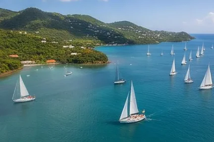
Wind here, next 7 days
The forecast loads as you scroll.
Hour by hour, waves and sunset → · Data: MET Norway (CC BY 4.0). Always check the official marine forecast before you leave.
Questions about Grenada and Carriacou
Why do cruisers spend hurricane season in Grenada?
It lies near the southern edge of the hurricane belt, with good yards and sheltered bays, but storms can still reach it; check your insurance terms.
Where can I haul out in Grenada?
There are several yards on the south coast and at St David's, and one in Tyrrel Bay on Carriacou.
Do I pay to moor at Sandy Island?
Yes, it is part of a marine protected area with moorings and a fee.
Cruising nearby
Written by the Boat Almanac editors from charts, official notices and boaters' reports; lists are updated from the almanac every day. Something changed? Suggest a correction.